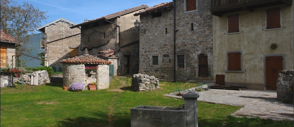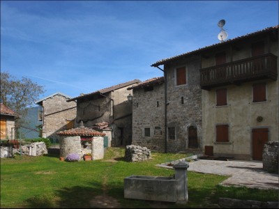
La contrada, posta a 835 metri di altezza, è un piccolo borgo di case strette le une alle altre, posto su un esteso falsopiano che da un lato si affaccia sulla sottostante Valle Brembilla e sui paesi di Roncola e dell’Albenza posti sul versante di fronte e, dall’altro, è incorniciato e protetto dai suoi monti.
Il nome "Cavaglia" proviene da una suggestiva leggenda e si rifà ad una postazione della cavalleria della regina Teodolinda, che avrebbe poi dato il nome anche al sovrastante monte (Castel Regina). La tradizione vuole inoltre che anche le stalle della "Forsèla di Buse" (Forcella dei Busi) e di “Passabuna” servissero da luoghi di sosta.
Nel ‘300 Cavaglia, insieme a Gerosa, faceva parte del Comune e Parrocchia di Brembilla. Dal 1442 e fino al 1779, sempre aggregata a Gerosa e con l’aggiunta di Gaiazzo, Passabuna e Cadelfoglia, si stacca da Brembilla, per poi rientrare a farne parte dal 1779 durante il periodo napoleonico.
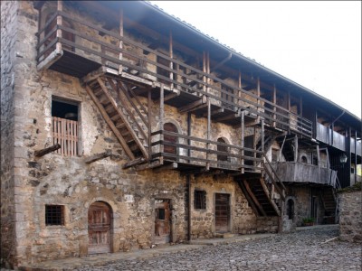
Dal punto di vista architettonico sono da notare le case in pietra caratterizzate da tetti in coppi, scale esterne per salire ai piani superiori in pietra e legno e le cosiddette ‘lobbie’ (terrazze) in legno, abbellite in estate dai gerani. Quasi tutte le porte sono ad arco e sulla pietra di una di queste vi è incisa la data del 1531. Al pianterreno si ritrovano invece stalle, cucine e un locale che farebbe pensare a una vecchia taverna con il tipico soffitto a ’silter’ in pietra di tufo.
La contrada è stata recentemente oggetto di una ristrutturazione che ha consentito di salvaguardare le caratteristiche architettoniche originarie dei borghi contadini di montagna della zona, specie nel centro dove vi è in bella mostra una grande casa cinquecentesca.
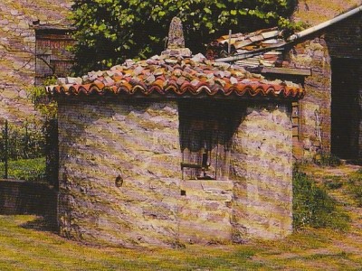
Interessanti anche le "sisterne" (cisterne, pozzi), tipiche dei borghi della Valle Brembilla e che servivano per l’approvvigionamento idrico: l’acqua piovana veniva convogliata in questi pozzi scavati nel terreno e rivestiti in muratura di diverse forme: circolare, quadrata, esagonale od ottagonale, e coperti da tetti spioventi o piatti, rivestiti di coppi o ‘piöde’. La prima che si può incontrare è situata appena entrati in Cavaglia dalla mulattiera ed è visibile sulla sinistra. Ogni famiglia aveva la propria ‘sisterna’ nella maggior parte funzionante ancor oggi. Una tra le meglio conservate è quella posta al centro del borgo, vicino alla casa cinquecentesca.
Da vedere anche la chiesetta, in stile neoclassico, che sorge su un pianoro posto sul lato destro dell’antico borgo e costruita nel 1901 sul luogo dove già esisteva un’edicola dedicata a San Martino. Nel 1859, su iniziativa di don Pietro Rota, si costruì una piccola cappella consacrata alla Vergine de La Salette il cui quadro fu portato dagli emigranti di Cavaglia di ritorno da Grenoble in Francia, dove la Madonna apparve appunto in quel periodo. Due volte l’anno, l’ultima domenica di Gennaio e il 15 Agosto, si svolge la consueta festa, caratterizzata dall'antica tradizione dell'incanto del trono e dalla processione della statua per le vie della contrada.
Presso i locali adiacenti la Chiesa è stato allestito un museo degli attrezzi agricoli. La visita alla collezione rappresenta un’occasione per fare un salto nel passato e ripercorrere alcuni momenti della vita contadina dei cavagliesi.
PERCORSI NATURALISTICI
Dal punto di vista escursionistico, Cavaglia rappresenta il punto di partenza perfetto per interessanti percorsi verso le sovrastanti montagne. E’ infatti possibile raggiungere le seguenti mete attraverso il sentiero CAI 596: la Corna Camoscera (conosciuta anche come “Còren”), mt.1343, caratterizzata da bianche pareti verticali in solido calcare e che si sviluppano per oltre 200 mt, il Pizzo Cerro, mt. 1285, Il Castel Regina, mt.1454, il Foldone, mt. 1502, sentiero CAI 595 e più in là il Sornadello, mt. 1580.
Da segnalare in particolare sul “Monte Còren” le falesie di arrampicata che sono state recentemente riqualificate e chiodate ad opera del gruppo di appassionati di arrampicata “Lucertole di Brembilla” e la storica ferrata della “Madonnina” aperta dal Gruppo “Amici del Monte Còren” sulla parete sud-ovest della Corna Camoscera e che permette di raggiungerne la vetta.
Altro percorso interessante parte da Brembilla, in località Capreduzzo e attraverso il sentiero CAI 592 C arriva a Cavaglia e devia scendendo da Gaiazzo verso la valle dei Faggi, ricca di sorgenti e delle tradizionali «Calchere», luoghi dove veniva cotto il sasso e trasformato in calce. Il percorso si conclude scendendo a Cadelfoglia e da lì di nuovo a Capreduzzo, luogo di partenza.
© 2024 Pro Loco Val Brembilla - Via Libertà, 29 24012 Val Brembilla (BG) - P.IVA 03826220166
388-7777354 - prolocobrembilla@gmail.com
| Privacy Policy


.png&w=50&h=50&zc=1)
.png&w=50&h=50&zc=1)
